


With the help of UAVs, it is more compatible & efficient to study the harnessing for basin to extract hydrocarbon resources. Moving to utility factors, the most widely used monitoring methods for oil and gas transmission pipelines are foot patrols along the pipeline route and aerial surveillance using light aircraft or UAVs. Patrols help to prevent placing pipelines, the surroundings, and the security of supplies at risk. However, they have to be carried out at regular intervals throughout the year, and regardless of weather conditions. The economic cost associated with these approaches is therefore also very high.
Our Services

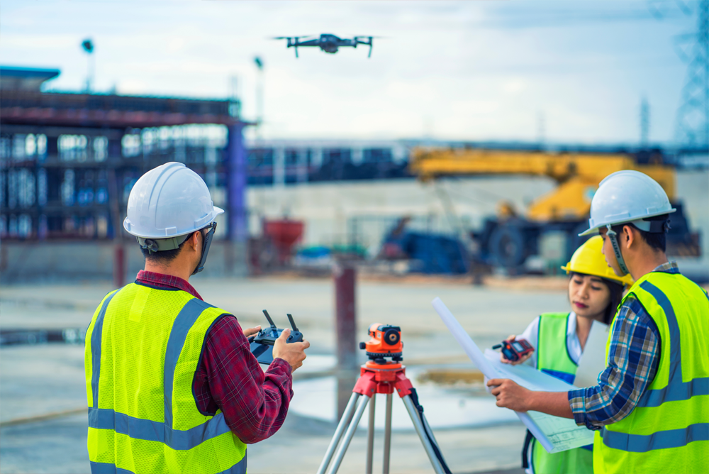
With their real-time data recording and unique aerial advantage, drones can improve efficiency, cut costs and streamline workflow. Here are some of the ways drones are used in construction. Due to their ability to map vast quantities of land, drones can exponentially cut down on time spent visualizing a site’s topography. This helps to keep the project on schedule and on budget and ensures accuracy before the project is initiated. Gathering this information can help determine feasibility and assist with design.The high-resolution images produced by drones can be converted into 3D models and help crew to pinpoint challenges.

One of the uses for drone imagery that has already been rolled out with great success is for monitoring plant health. Drones equipped with special imaging equipment called Normalized Difference Vegetation Index (NDVI) use detailed colour information to indicate plant health. This allows farmers to monitor crops as they grow so any problems can be dealt with fast enough to save the plants. This image illustrates simply how NDVI works. Drone field monitoring is also being used to monitor the health of soil and field conditions.This allows for precise application of fertilizers,eliminating poor growing spots and improving soil health.

In the past few years, drones have emerged as an essential tool in the energy sector for monitoring and surveilling power plant assets such as buildings, equipment, and other systems that ensure safe, efficient operations. Today, inspectors use drones to monitor thermal, nuclear, hydroelectric, wind, and solar assets more safely and often in less time when compared with traditional inspection and other remote monitoring methods.In addition to safety and efficiency, drones also allow for more frequent monitoring. Not only are they an ideal choice for time-critical inspections, but they also enable more strategic planned maintenance.

The mining industry has quickly adopted drone technology due to its ability to improve data collection, increase safety, and reduce operational expenses.Drone that is specifically designed for or tailored for mining applications, like stockpile measurement, surveying, mapping, and inspections.Mining is a hazardous profession, as worksite conditions can change instantly. Both underground and surface mining will present unique challenges and inherent risks. While drones will not eliminate every danger associated with traditional mining practices, they can be deployed to collect data in areas where humans are not allowed to enter.

Drones can go places that no other devices can, and in ways that even the most sophisticated photography equipment simply can’t match. From 200 feet up in the air, a rock-solid steady shot can be filmed by a drone, which is something that simply couldn’t be done until very recently. The only thing even close to that would have been a helicopter shot, and helicopters are so big and bulky that they simply can’t get into all the places that drones can, nor can they fly as low.The kind of fluid, gliding sequences that drones can film, allow filmmakers to really expand the creative boundaries of the profession , creating scenes that until now could only be imagined.

Drones generally offer a low-cost and easy to use means of collecting high-quality geospatial data after disaster. In many countries and scenarios, drones represent the only realistic or affordable means of collecting aerial imagery: manned aircraft and usable satellite images are not options. Drones permit disaster responders to quickly create usable, actionable maps, and to rapidly impact a disaster’s effects on the community.Drone-collected data makes it easier and cheaper for organizations to plan future construction and infrastructure projects. With drone data, organizations can identify better places for relief camps, assess flood risk in a given area, predict and plan for climate change impacts.

Autonomous harbour vessels could transport pilots effectively to ships and remain on standby for emergency response, unmanned vessels be used to transport cargo on inland waterways in the future, while autonomous navigation technology could help tug masters assist ships into berths. In the air and subsea, drones could be used for mapping, surveying and environmental monitoring.Port authorities and vessel owners have tested autonomous navigation on tugs to improve handling of ships and transiting between towing jobs. The latest trials have been completed in Singapore and Rotterdam, the Netherlands.

As this technology expands, we expect businesses to be able to deliver goods more safely, more efficiently, faster, and at a lower cost than conventional road transportation. Right now, last-mile delivery accounts for over 50% of the total cost to ship a good. In the next decade, the number of last-mile delivery vehicles on our roads is set to grow by 36%, increasing emissions by 30% and adding 11 minutes to the average commute, according to the World Economic Forum.By leveraging the underutilized space above us, drone delivery can lessen our reliance on the ground beneath us, cutting costs and emissions, reducing congestion, and making our roads safer.

Drones generally offer a low-cost and easy to use means of collecting high-quality geospatial data after disaster. In many countries and scenarios, drones represent the only realistic or affordable means of collecting aerial imagery: manned aircraft and usable satellite images are not options. Drones permit disaster responders to quickly create usable, actionable maps, and to rapidly impact a disaster’s effects on the community.Drone-collected data makes it easier and cheaper for organizations to plan future construction and infrastructure projects. With drone data, organizations can identify better places for relief camps, assess flood risk in a given area, predict and plan for climate change impacts.
Autonomous harbour vessels could transport pilots effectively to ships and remain on standby for emergency response, unmanned vessels be used to transport cargo on inland waterways in the future, while autonomous navigation technology could help tug masters assist ships into berths. In the air and subsea, drones could be used for mapping, surveying and environmental monitoring.Port authorities and vessel owners have tested autonomous navigation on tugs to improve handling of ships and transiting between towing jobs. The latest trials have been completed in Singapore and Rotterdam, the Netherlands.

As this technology expands, we expect businesses to be able to deliver goods more safely, more efficiently, faster, and at a lower cost than conventional road transportation. Right now, last-mile delivery accounts for over 50% of the total cost to ship a good. In the next decade, the number of last-mile delivery vehicles on our roads is set to grow by 36%, increasing emissions by 30% and adding 11 minutes to the average commute, according to the World Economic Forum.By leveraging the underutilized space above us, drone delivery can lessen our reliance on the ground beneath us, cutting costs and emissions, reducing congestion, and making our roads safer.
Hurry up! Contact us today and get
PRODUCT DEMO